China's Gaofen-7 satellite put into service
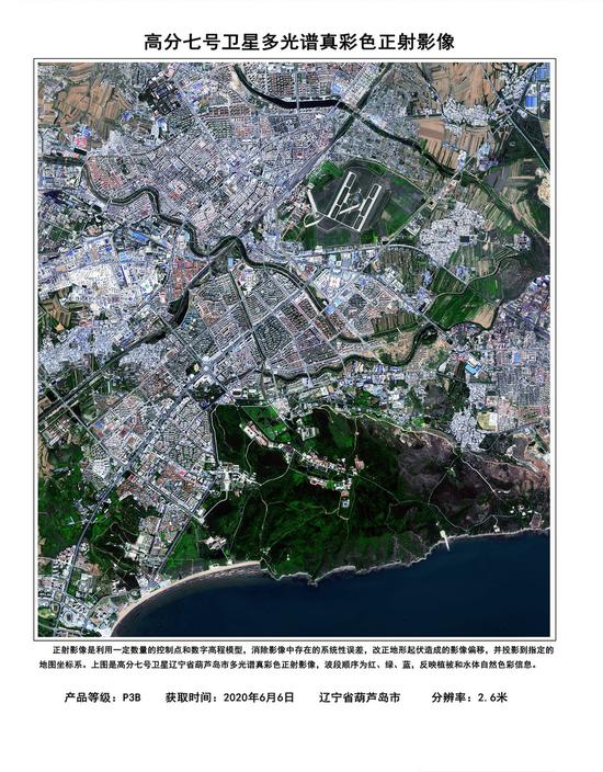
Image obtained by the Gaofen-7 Earth observation satellite on June 6, 2020 shows a view of Huludao City in northeast China's Liaoning Province. (China National Space Administration/Handout via Xinhua)
The China National Space Administration announced on Thursday that the Gaofen-7 Earth observation satellite has been put into service, representing significant progress for the country's surveying and mapping capabilities.
Launched on Nov. 3, 2019, Gaofen-7 is China's first civil-use optical transmission 3D surveying and mapping satellite that reaches the sub-meter level.
Equipped with two line-scan cameras and a laser altimeter, the satellite can provide 1:10,000 scale satellite 3D mapping for users in China and countries participating in the Belt and Road Initiative.
During in-orbit tests, satellite functions such as the monitoring of geographical conditions, agricultural surveys, and road constructions have been verified, said Zhang Kejian, head of the administration.
In May, using data from the Gaofen-7 and Ziyuan III satellites, scientists drew a 1:10,000 scale topographic map for surveyors to measure the height of Mount Qomolangma.
Since the Gaofen project began in 2010, China has had an increasingly clearer view of the planet. According to the administration, data from the Gaofen series of satellites have been used in more than 20 industries across the country.
Images captured by the Gaofen-2 satellite were used to help monitor the construction work of two makeshift hospitals, Huoshenshan and Leishenshan, in Wuhan, after the COVID-19 outbreak.
Gaofen-3 has contributed to the monitoring of the flood situation along Poyang Lake, China's largest freshwater lake, in the eastern province of Jiangxi.
With Gaofen satellite data, researchers also conducted ecological environment investigations for poor areas in the northwestern province of Gansu.
"Gaofen-7 will further meet the needs of users in basic mapping, global geographic information, monitoring, and evaluation in urban and rural construction, etc.," said Zhang.